Indian Navy commemorates World Hydrography Day centenary
The Indian Navy commemorated the centenary of the World Hydrography Day on 21 June through a series of coordinated events at the respective commands to spread awareness in the subject and its contribution to ensuring safe navigation at sea

The Indian Navy commemorated the centenary of the World Hydrography Day on 21 June through a series of coordinated events at the respective commands to spread awareness in the subject and its contribution to ensuring safe navigation at sea.
The theme for the event this year was "100 years of international cooperation in hydrography".
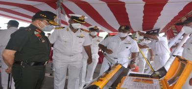
Lieutenant General Ajai Singh, Commander-in-Chief Andaman & Nicobar Command (CINCAN) participated in commemorating the day through showcasing of achievements and contributions of the Indian Naval Hydrographic Organisation (INHO).
The CINCAN appreciated the yeoman service by the INHO in capacity-building initiatives among littorals in the Indian Ocean Region through hydrographic surveys and providing world-class training to personnel from friendly foreign nations.
The surveys help in augmenting the Sagarmala project under the NITI Aayog for sustainable development of A&N Islands.
The hydrographic survey unit at Port Blair is responsible for the surveys around the A&N Islands and is fully equipped with state-of-the-art equipment for the conduct, analysis and preparation of reports of hydrographic surveys. HSU (PBR) participates in various joint operations with the Indian Army and Indian Air Force within the Andaman and Nicobar Command.
The Unit has successfully conducted surveys for RCS 3.0 – UDAN, the prestigious Government of India project under regional connectivity by playing a vital role in identifying suitable seaplane landing sites at four locations in the Andaman group of islands at Shaheed Dweep, Swaraj Dweep, Hut Bay and Long Island, which will boost regional connectivity and tourism.
Indian Navy hydrography ships Sutlej from Southern Naval Command and Nirupak from Eastern Naval Command are currently deployed for hydrographic survey in Andaman and Nicobar Islands.
These ships utilize state-of-the-art multi-beam bathymetric data acquisition systems to survey and update navigational charts of the A&N Islands. All Covid protocol measures were followed by the personnel present at the event.
Hydrography is the science that measures and describes the physical features of bodies of water and the land areas adjacent to those bodies of water.
Surveying with multibeam echo sounders is the primary method of obtaining hydrographic data. By mapping out water depth, the shape of the seafloor and coastline, the location of possible obstructions and physical features of water bodies, hydrography helps to keep our maritime transportation system moving safely and efficiently.
Multibeam echo sounder beams sweep the seafloor as the ship passes over the survey area. Multibeam echo sounder beams bounce off the seafloor and return to the ship where the depth is recorded.
Hydrographers measure water depth and search for shoals, rocks, and wrecks/sunken ships that could be hazards to navigation. They also collect information on water levels and tides, currents, temperature and salinity. The survey is useful in making nautical charts essential for safe marine navigation as well as hydrographic models which provide baseline data for research and marine geospatial products and services.
(The author, a strategic analyst, is a former spokesperson, India's Ministry of Defence. He can be contacted at wordsword02@gmail.com)


Post a Comment