
Months Ahead of the Monsoon: Can AI Give Us an Earlier Warning About El Niño?
AI may genuinely extend the horizon over which seasonal climate risk can be estimated. For communities across South Asia living under the influence of the monsoon, a longer view could mean the difference between a farmer adjusting her planting in time and a family receiving a flood warning too late to act.
 Sep 28, 2026

Imagine a farmer in Madhya Pradesh in India watching the sky in June. The southwest monsoon, the seasonal rain that fills her wells, greens her fields and feeds her family has arrived late. Thousands of miles to the east, in the tropical Pacific Ocean, a vast patch of unusually warm water has been building for months. Nobody told her. By the time the data reached a forecast, and the forecast reached a warning, the planting window had narrowed.
This is the problem that a new generation of climate scientists and AI researchers is trying to solve: can we read the Pacific's signal earlier months, or more than a year, ahead and translate it into information that communities can actually act on?
The Ocean's Slow Heartbeat
ENSO, the El Niño Southern Oscillation is a recurring cycle in which the tropical Pacific Ocean and the atmosphere above it exchange energy in a vast, slow exchange that climate scientists sometimes compare to a planetary heartbeat. During El Niño, the trade winds that normally blow westward weaken; unusually warm water spreads eastward across the Pacific and atmospheric pressure patterns shift across the tropics. During La Niña, the opposite occurs. A full cycle typically takes two to seven years.
These changes do not stay in the Pacific. Through pathways scientists call teleconnections shifts in jet streams, moisture transport and large-scale pressure systems. ENSO influences weather patterns across much of the globe. But the effects are not simple rules; they depend on the season, local geography and the presence of other climate patterns, most notably the Indian Ocean Dipole (IOD), which describes temperature contrasts between the western and eastern Indian Ocean. ENSO shifts probabilities and background conditions. It does not determine every local weather event.
Four Countries, Four Risks
For Sri Lanka, which receives rainfall in four distinct seasons, ENSO and the IOD together influence whether river basins such as the Mahaweli and Kelani fill adequately for irrigation. Cyclone Ditwah brought devastating floods and landslides in November 2025; WHO reported 410 confirmed deaths as of 2 December. (Sources said : Sri Lanka Dept of Meteorology, WHO)
For India, El Niño is associated with an increased probability of a weaker southwest monsoon, the rainfall on which hundreds of millions of people depend for drinking water and food production. The question for planners is not simply whether it is an El Niño year, but where risks of water shortage, heat and erratic rainfall are most likely to concentrate, and how far ahead that information can arrive. (Sources said: India Meteorological Department, World Meteorological Organization)
For Bangladesh, the concern is what happens upstream, beyond its borders. The country sits at the downstream end of a vast river system fed by rainfall across multiple countries. During the August 2024 eastern Bangladesh floods, a UNICEF situation report recorded twenty deaths while the emergency was still unfolding. Useful warnings require climate signals combined with river data from across the entire shared basin. (Sources said: Bangladesh Meteorological Department, UNICEF)
For Nepal, steep Himalayan terrain means that sudden mountain events ice fall, landslides, glacial lake breaches can send destructive surges downstream within hours. The August 2026 flash flood in Rasuwa district is a case in point: scientists suspected a collapse event caused a surge through the Bhote Koshi and Trishuli rivers; ICIMOD's initial assessment noted the immediate trigger remained under investigation. Protecting these communities requires glacier, slope and river monitoring alongside any seasonal climate outlook. (Sources said: ICIMOD, World Meteorological Organization).
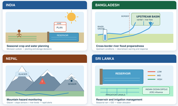
Turning climate risk into local action. An AI-informed forecast means something different in each country: crop and water planning in India; cross-border flood preparedness in Bangladesh; mountain hazard monitoring in Nepal; reservoir management in Sri Lanka. In every case, decisions are made by people and not by the AI.
“ENSO shifts probabilities and background conditions. El Niño does not guarantee drought; La Niña does not guarantee flood. Each step from the Pacific signal to a local community carries additional uncertainty.”
What AI Brings to the Table
Traditional ENSO forecasting uses physical models run on supercomputers, delivering genuine skill at six to nine months but typically declining beyond that range. AI researchers are now exploring whether deep learning can identify patterns in large climate datasets that complement and sometimes extend what physical models can achieve. Three approaches have emerged from recent research.
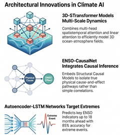
First, three-dimensional spatiotemporal models treat the ocean and atmosphere as a coupled system, incorporating temperature, pressure and wind at multiple depths and altitudes simultaneously; multi-head attention mechanisms allow these models to scan patterns at different spatial and time scales at once. Second, causal inference networks such as structural causal models attempt to identify physically meaningful cause and effect pathways rather than mere statistical associations, making predictions less vulnerable to spurious correlations. Third, autoencoder LSTM networks compress vast climate datasets into representative patterns and track how those patterns evolve through time, with reported results suggesting the capability to identify extreme ENSO indicators up to 18 months ahead with around 85 % accuracy under specific test conditions.
These approaches also point toward a multi-stage forecasting pipeline: first estimate the probable ENSO state months ahead; then combine that with regional drivers, especially the IOD; then integrate local observations rainfall, river gauges, reservoir levels, satellite data, glacier monitoring; and finally produce a probabilistic risk estimate that trained professionals can translate into a location-specific, actionable warning.
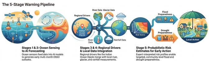
In this figure, closing the gap between the pacific and the village. Five stages translate a pacific climate signal into a local warning. Each step adds local detail and additional uncertainty. The final output is a probabilistic risk estimate, not a guaranteed prediction.
What AI Can and Cannot Tell Us
AI can find patterns across vast ocean and atmospheric datasets, potentially extending useful ENSO forecasts. Combined with regional observations, those forecasts can provide probabilities that help communities plan for climate risks. But AI cannot promise a flood on a particular date or remove the uncertainty that grows over longer forecast periods. River gauges, glacier and reservoir monitoring, local knowledge and expert judgement remain essential and people, not algorithms, must decide when and how to act.
A Tool, Not an Oracle
AI forecasting systems are tools for trained professionals, not replacements for them. A probability estimate must be interpreted, communicated and acted upon by meteorologists, hydrologists, disaster managers and communities whose local knowledge no model yet fully captures. Warnings must be understandable: a PCC value means nothing to a farmer deciding whether to plant, or a family deciding whether to move to higher ground. Communication systems must translate probabilistic information into clear guidance about what to do, why and when in the right language, through a trusted channel, with enough lead time for action to be possible.
Forecast systems should also be independently evaluated, transparently documented and monitored for bias. A model trained on data from one region or one historical period may not generalize reliably to other places or to a climate that is itself changing as greenhouse gas concentrations rise.
The Chain That Saves Lives
AI may genuinely extend the horizon over which seasonal climate risk can be estimated. The research suggests lead times of a year or more are achievable for broad ENSO-state prediction with skill that is real, imperfect and declining as the window lengthens. For communities across South Asia living under the influence of the monsoon, a longer view could mean the difference between a farmer adjusting her planting in time and a family receiving a flood warning too late to act.
“AI may lengthen the first link in the chain. Completing the rest requires observation networks, cross-border data sharing, community communication and the institutional trust that no algorithm can substitute for.”
A credible ENSO forecast must become a regional outlook. A regional outlook must be downscaled to local conditions. A local risk estimate must become a warning. And a warning must reach the right people, in language they trust, with time to make a difference. Technology provides an earlier view. People, institutions and communities decide what to do with it.
(The author is an Associate Professor in Generative AI and Machine Learning and leader of the AI for Climate & Disaster Resilience Research Group (AICDRG) at York St John University, UK. He is at the forefront of South Asia's regional transformation in AI research and application. The views expressed are personal.)





Post a Comment